
Make a donation
Gear up for your next adventure:
As an Amazon Associate, this site earns from qualifying purchases at no extra cost to you.
Balmoral topographic map
Click on the map to display elevation.
Make a donation
Gear up for your next adventure:
As an Amazon Associate, this site earns from qualifying purchases at no extra cost to you.
About this map
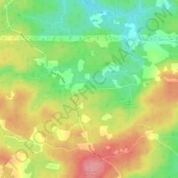
Name: Balmoral topographic map, elevation, terrain.
Average elevation: 55 m
Minimum elevation: 1 m
Maximum elevation: 112 m
Make a donation
Gear up for your next adventure:
As an Amazon Associate, this site earns from qualifying purchases at no extra cost to you.
Other topographic maps
Click on a map to view its topography, its elevation and its terrain.
Bras d'Or Lake
Canada > Nova Scotia > Municipality of the County of Richmond > Red Islands
Average elevation: 29 m
Flat Rock
Canada > Nova Scotia > Municipality of the County of Richmond > Grand River
Average elevation: 5 m
Make a donation
Gear up for your next adventure:
As an Amazon Associate, this site earns from qualifying purchases at no extra cost to you.