
Mathangauta topographic map
Interactive map
Click on the map to display elevation.
About this map
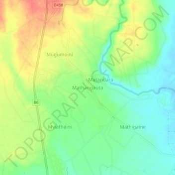
Name: Mathangauta topographic map, elevation, terrain.
Location: Mathangauta, Mwea East, Kirinyaga County, Central Kenya, Kenya (-0.66101 37.35298 -0.62101 37.39298)
Average elevation: 1,173 m
Minimum elevation: 1,147 m
Maximum elevation: 1,206 m
Other topographic maps
Click on a map to view its topography, its elevation and its terrain.