
Make a donation
Gear up for your next adventure:
As an Amazon Associate, this site earns from qualifying purchases at no extra cost to you.
Sylhet topographic map
Click on the map to display elevation.
Make a donation
Gear up for your next adventure:
As an Amazon Associate, this site earns from qualifying purchases at no extra cost to you.
Sylhet
The name of Sylhet descended from Sanskrit word Srihatta (श्रीहट्ट / শ্রীহট্ট) which literally means elegant market. The name Sylhet is an anglicisation of Shilhot (শিলহট). Its origins seem to come from the Sanskrit according to the words of শিলা śilā (meaning stone) and হট্ট haṭṭa (meaning marketplace). These words match the landscape and topography of the hilly region. The shila stones were abundant across Sylhet and the King Gour Govinda is known to have used stones to guard his capital. The word had changed to Shilhot due to the elision of letter-final অ ô in the Bengali language.
Make a donation
Gear up for your next adventure:
As an Amazon Associate, this site earns from qualifying purchases at no extra cost to you.
About this map
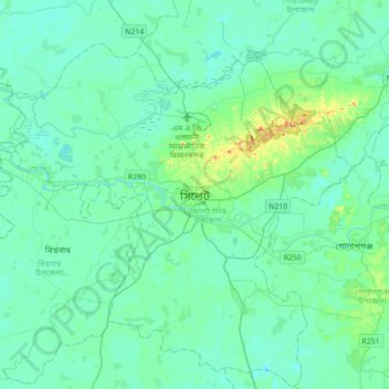
Name: Sylhet topographic map, elevation, terrain.
Average elevation: 14 m
Minimum elevation: 4 m
Maximum elevation: 66 m
Make a donation
Gear up for your next adventure:
As an Amazon Associate, this site earns from qualifying purchases at no extra cost to you.