
Matute topographic map
Interactive map
Click on the map to display elevation.
About this map
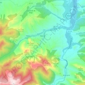
Name: Matute topographic map, elevation, terrain.
Location: Matute, La Rioja, España (42.25199 -2.84721 42.33238 -2.75564)
Average elevation: 854 m
Minimum elevation: 544 m
Maximum elevation: 1,561 m
Other topographic maps
Click on a map to view its topography, its elevation and its terrain.
San Martín
España > La Rioja > Santa Engracia del Jubera
San Martín, Santa Engracia del Jubera, La Rioja, España
Average elevation: 829 m
San Millán de la Cogolla
España > La Rioja > San Millán de la Cogolla
San Millán de la Cogolla, La Rioja, España
Average elevation: 1,053 m