
Make a donation
Gear up for your next adventure:
As an Amazon Associate, this site earns from qualifying purchases at no extra cost to you.
Chalmette topographic map
Click on the map to display elevation.
Make a donation
Gear up for your next adventure:
As an Amazon Associate, this site earns from qualifying purchases at no extra cost to you.
Chalmette
Chalmette is located at 29°56′44″N 89°57′42″W / 29.94556°N 89.96167°W / 29.94556; -89.96167 (29.945504, -89.961602), along the Mississippi River and has an elevation of 3 feet (0.9 m). It is located east of New Orleans, and is part of the Greater New Orleans area. According to the United States Census Bureau, the CDP has a total area of 7.9 square miles (20 km2), of which 7.3 square miles (19 km2) is land, and 0.6 square miles (1.6 km2) (7.56%) is water.
Make a donation
Gear up for your next adventure:
As an Amazon Associate, this site earns from qualifying purchases at no extra cost to you.
About this map
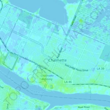
Name: Chalmette topographic map, elevation, terrain.
Average elevation: 1 m
Minimum elevation: -4 m
Maximum elevation: 11 m
Make a donation
Gear up for your next adventure:
As an Amazon Associate, this site earns from qualifying purchases at no extra cost to you.
Other topographic maps
Click on a map to view its topography, its elevation and its terrain.