
Make a donation
Gear up for your next adventure:
As an Amazon Associate, this site earns from qualifying purchases at no extra cost to you.
Toro Toro topographic map
Click on the map to display elevation.
Make a donation
Gear up for your next adventure:
As an Amazon Associate, this site earns from qualifying purchases at no extra cost to you.
Toro Toro
Torotoro lies at an altitude of 2,676 m. It can only be reached by road from Estancia Sucusuma at the Río Caine. The town is at the centre of Torotoro National Park. It is 140 km south of Cochabamba.
Make a donation
Gear up for your next adventure:
As an Amazon Associate, this site earns from qualifying purchases at no extra cost to you.
About this map
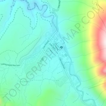
Name: Toro Toro topographic map, elevation, terrain.
Average elevation: 2,792 m
Minimum elevation: 2,657 m
Maximum elevation: 3,179 m
Make a donation
Gear up for your next adventure:
As an Amazon Associate, this site earns from qualifying purchases at no extra cost to you.
Other topographic maps
Click on a map to view its topography, its elevation and its terrain.
Mirador Arco de piedra
Bolivia > Potosí > Provincia Charcas > Municipio Toro Toro
Average elevation: 3,547 m