Geolocate

Tukod topographic map

Click on the map to display elevation.

About this map

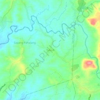
Name: Tukod topographic map, elevation, terrain.

Location: Tukod, San Rafael, Bulacan, Central Luzon, Philippines (14.97451 121.02935 15.01451 121.06935)

Average elevation: 79 m

Minimum elevation: 48 m

Maximum elevation: 164 m

Other topographic maps

Click on a map to view its topography, its elevation and its terrain.

Maguinao

Philippines > Bulacan > San Rafael

Average elevation: 32 m

Capihan

Philippines > Bulacan > San Rafael

Average elevation: 21 m

Talacsan

Philippines > Bulacan > San Rafael

Average elevation: 30 m

Libis

Philippines > Bulacan > San Rafael

Average elevation: 28 m

Maasim

Philippines > Bulacan > San Rafael

Average elevation: 19 m

Maronquillo

Philippines > Bulacan > San Rafael

Average elevation: 30 m

Caingin

Philippines > Bulacan > San Rafael

Average elevation: 31 m

Pinacpinacan

Philippines > Bulacan > San Rafael

Average elevation: 19 m

Diliman I

Philippines > Bulacan > San Rafael

Average elevation: 24 m

Talacsan

Philippines > Bulacan > San Rafael

Average elevation: 30 m

Gear up for your next adventure:

🎒Hiking Daypacks - Compact backpacks ideal for short hikes and excursions
🍲Portable Camping Stoves - Fast-boiling stoves for hot meals on remote topographic survey trips
🧊Personal Water Filters - Drink safely from mountain streams marked on your map
🔥Reusable Hand Warmers - Maintain dexterity in your fingers for precise map handling
🧰First Aid Kits - Essential safety kits for outdoor activities

As an Amazon Associate, this site earns from qualifying purchases at no extra cost to you.