
Πηνειός topographic map
Interactive map
Click on the map to display elevation.
About this map
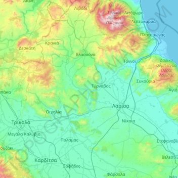
Name: Πηνειός topographic map, elevation, terrain.
Average elevation: 409 m
Minimum elevation: -2 m
Maximum elevation: 2,852 m
Other topographic maps
Click on a map to view its topography, its elevation and its terrain.
Larisa
Griechenland > Thessalien - Mittelgriechenland > Regionalbezirk Larisa
Larisa, Δημοτική Ενότητα Λαρισαίων, Δήμος Λαρισαίων, Regionalbezirk Larisa, Region Thessalien, Thessalien - Mittelgriechenland, 422 22, Griechenland
Average elevation: 128 m
Thessalien - Mittelgriechenland
Griechenland > Thessalien - Mittelgriechenland
Thessalien - Mittelgriechenland, Griechenland
Average elevation: 367 m