
Make a donation
Gear up for your next adventure:
As an Amazon Associate, this site earns from qualifying purchases at no extra cost to you.
Surami topographic map
Click on the map to display elevation.
Make a donation
Gear up for your next adventure:
As an Amazon Associate, this site earns from qualifying purchases at no extra cost to you.
About this map
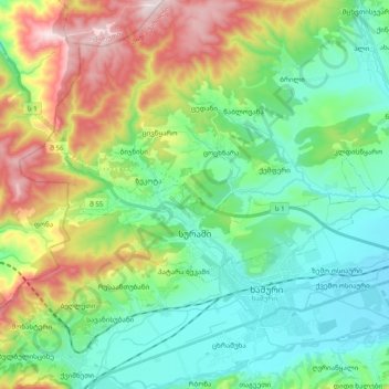
Name: Surami topographic map, elevation, terrain.
Location: Surami, Khashuri Municipality, Shida Kartli, Georgia (41.99961 43.47487 42.06511 43.66984)
Average elevation: 870 m
Minimum elevation: 676 m
Maximum elevation: 1,308 m
Make a donation
Gear up for your next adventure:
As an Amazon Associate, this site earns from qualifying purchases at no extra cost to you.
Other topographic maps
Click on a map to view its topography, its elevation and its terrain.
Mtkvari
Georgia > Shida Kartli > Khashuri Municipality > Rbona
Most of the Kura runs in the broad and deep valley between the Greater Caucasus and Lesser Caucasus Mountains, and the major tributary, the Aras, drains most of the southern Caucasus and the mountain ranges of the extreme northern Middle East. The entirety of Armenia and most of Azerbaijan are drained by the…
Average elevation: 781 m