
Blaustein topographic map
Interactive map
Click on the map to display elevation.
Blaustein
Blaustein is west from Ulm, nestled between Hochsträß, Blautal, Lautertal and the plateau of the Swabian Jura. The town lies at an altitude of 490-690 meters. The rivers Blau and Lauter – which arises in Blaustein (Lautern) – flow through the city.
About this map
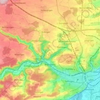
Name: Blaustein topographic map, elevation, terrain.
Location: Blaustein, Alb-Donau-Kreis, Baden-Württemberg, 89134, Germany (48.37302 9.79758 48.49346 9.94277)
Average elevation: 584 m
Minimum elevation: 464 m
Maximum elevation: 716 m