
Make a donation
Gear up for your next adventure:
As an Amazon Associate, this site earns from qualifying purchases at no extra cost to you.
Benevento topographic map
Click on the map to display elevation.
Make a donation
Gear up for your next adventure:
As an Amazon Associate, this site earns from qualifying purchases at no extra cost to you.
Benevento
Pacevecchia è detta anche la "zona alta" di Benevento, essendo l'area a maggiore altitudine della città: è ivi locato l'osservatorio astronomico del Sannio e il centro MARSec.
Make a donation
Gear up for your next adventure:
As an Amazon Associate, this site earns from qualifying purchases at no extra cost to you.
About this map
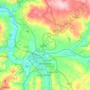
Name: Benevento topographic map, elevation, terrain.
Location: Benevento, Campania, Italia (41.09016 14.70902 41.22481 14.86969)
Average elevation: 250 m
Minimum elevation: 76 m
Maximum elevation: 564 m
Make a donation
Gear up for your next adventure:
As an Amazon Associate, this site earns from qualifying purchases at no extra cost to you.
Other topographic maps
Click on a map to view its topography, its elevation and its terrain.
Make a donation
Gear up for your next adventure:
As an Amazon Associate, this site earns from qualifying purchases at no extra cost to you.