
Make a donation
Gear up for your next adventure:
As an Amazon Associate, this site earns from qualifying purchases at no extra cost to you.
Distrito de Nole Duima topographic map
Click on the map to display elevation.
Make a donation
Gear up for your next adventure:
As an Amazon Associate, this site earns from qualifying purchases at no extra cost to you.
About this map
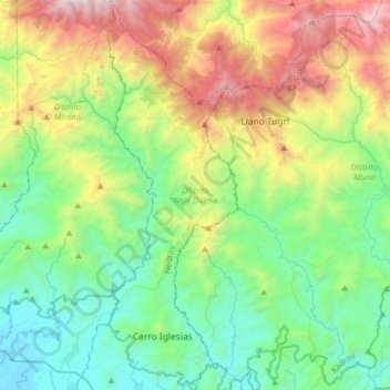
Name: Distrito de Nole Duima topographic map, elevation, terrain.
Location: Distrito de Nole Duima, Ngäbe-Buglé, Panamá (8.26290 -81.84168 8.57768 -81.73388)
Average elevation: 716 m
Minimum elevation: 1 m
Maximum elevation: 2,372 m
Make a donation
Gear up for your next adventure:
As an Amazon Associate, this site earns from qualifying purchases at no extra cost to you.
Other topographic maps
Click on a map to view its topography, its elevation and its terrain.
Cerro Viejo Abajo
Panamá > Ngäbe-Buglé > Distrito Besikó > Emplanada de Chorcha
Average elevation: 260 m
Make a donation
Gear up for your next adventure:
As an Amazon Associate, this site earns from qualifying purchases at no extra cost to you.