
Vellor Ela Thodu topographic map
Interactive map
Click on the map to display elevation.
About this map
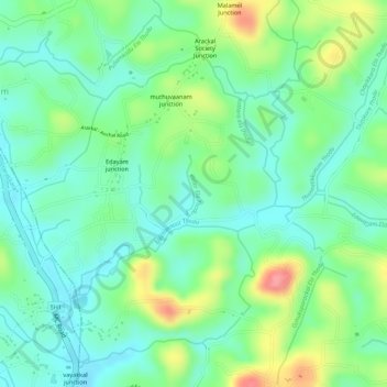
Name: Vellor Ela Thodu topographic map, elevation, terrain.
Location: Vellor Ela Thodu, Punalur, Kollam, Kerala, 691548, India (8.93596 76.86272 8.94040 76.86326)
Average elevation: 77 m
Minimum elevation: 44 m
Maximum elevation: 137 m
Other topographic maps
Click on a map to view its topography, its elevation and its terrain.
Punalur
Punalur has an average elevation of 56 metres (184 ft). Many tourists have visited scenic spots along the Kallada River. The Palaruvi Falls is 35 kilometres (22 mi) from Punalur. The first planned eco-tourism project in Kerala is only 20 kilometres (12 mi) from Punalur on NH 744 towards Sengottai.
Average elevation: 63 m