
Make a donation
Gear up for your next adventure:
As an Amazon Associate, this site earns from qualifying purchases at no extra cost to you.
Herndon topographic map
Click on the map to display elevation.
Make a donation
Gear up for your next adventure:
As an Amazon Associate, this site earns from qualifying purchases at no extra cost to you.
About this map
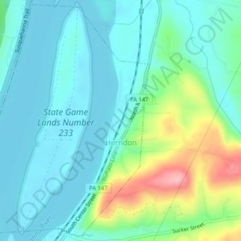
Name: Herndon topographic map, elevation, terrain.
Location: Herndon, Northumberland County, Pennsylvania, United States (40.69890 -76.86922 40.72496 -76.83823)
Average elevation: 156 m
Minimum elevation: 121 m
Maximum elevation: 272 m
Make a donation
Gear up for your next adventure:
As an Amazon Associate, this site earns from qualifying purchases at no extra cost to you.
Other topographic maps
Click on a map to view its topography, its elevation and its terrain.
Dalmatia
United States > Pennsylvania > Northumberland County > Lower Mahanoy Township
Average elevation: 172 m
Dalmatia
United States > Pennsylvania > Northumberland County > Lower Mahanoy Township
Average elevation: 172 m
Overlook
United States > Pennsylvania > Northumberland County > Ralpho Township
Average elevation: 261 m
Make a donation
Gear up for your next adventure:
As an Amazon Associate, this site earns from qualifying purchases at no extra cost to you.
Dalmatia
United States > Pennsylvania > Northumberland County > Lower Mahanoy Township
Average elevation: 172 m
Snufftown
United States > Pennsylvania > Northumberland County > Ralpho Township
Average elevation: 215 m
Atlas
United States > Pennsylvania > Northumberland County > Mount Carmel Township
Average elevation: 385 m