
Make a donation
Gear up for your next adventure:
As an Amazon Associate, this site earns from qualifying purchases at no extra cost to you.
Paradise topographic map
Click on the map to display elevation.
Make a donation
Gear up for your next adventure:
As an Amazon Associate, this site earns from qualifying purchases at no extra cost to you.
About this map
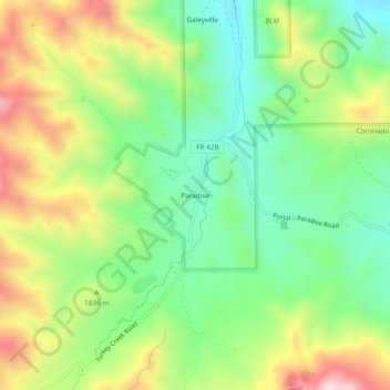
Name: Paradise topographic map, elevation, terrain.
Location: Paradise, Cochise County, Arizona, United States (31.91481 -109.23895 31.95481 -109.19895)
Average elevation: 1,783 m
Minimum elevation: 1,578 m
Maximum elevation: 2,098 m
Make a donation
Gear up for your next adventure:
As an Amazon Associate, this site earns from qualifying purchases at no extra cost to you.
Other topographic maps
Click on a map to view its topography, its elevation and its terrain.
Make a donation
Gear up for your next adventure:
As an Amazon Associate, this site earns from qualifying purchases at no extra cost to you.
Kartchner Caverns State Park
United States > Arizona > Cochise County > Benson
Average elevation: 1,432 m