
Make a donation
Gear up for your next adventure:
As an Amazon Associate, this site earns from qualifying purchases at no extra cost to you.
Mondarrain topographic map
Click on the map to display elevation.
Make a donation
Gear up for your next adventure:
As an Amazon Associate, this site earns from qualifying purchases at no extra cost to you.
Mondarrain
Le Mondarrain (Arranomendi en basque) est un mont du Pays basque français, au sud d'Espelette et au sud-ouest d'Itxassou, dans la province du Labourd, culminant à 749 m d'altitude dans le département des Pyrénées-Atlantiques en région Nouvelle-Aquitaine.
Make a donation
Gear up for your next adventure:
As an Amazon Associate, this site earns from qualifying purchases at no extra cost to you.
About this map
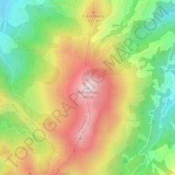
Name: Mondarrain topographic map, elevation, terrain.
Average elevation: 412 m
Minimum elevation: 126 m
Maximum elevation: 731 m
Make a donation
Gear up for your next adventure:
As an Amazon Associate, this site earns from qualifying purchases at no extra cost to you.