
Bachtel topographic map
Interactive map
Click on the map to display elevation.
Bachtel
Südöstlich, unterhalb des Gipfels, liegt auf ca. 955 Meter Höhe der Bachtelspalt . Es handelt sich um eine Spalte, die 1939 beim Abrutschen eines NagelfluhKopfes entstand. Sie ist begehbar, aber sehr eng.
About this map
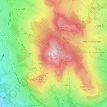
Name: Bachtel topographic map, elevation, terrain.
Location: Bachtel, Hinwil, Bezirk Hinwil, Zürich, 8342, Schweiz (47.29414 8.88568 47.29424 8.88578)
Average elevation: 868 m
Minimum elevation: 622 m
Maximum elevation: 1,112 m
Other topographic maps
Click on a map to view its topography, its elevation and its terrain.