
Lake Assal topographic map
Interactive map
Click on the map to display elevation.
Lake Assal
Lake Assal is located in the middle of Djibouti, in a closed depression at the northern end of the Great Rift Valley. Situated in the Danakil Desert, it is bounded by hills on the western region. The lake lies at an elevation of 155 m (509 ft) below sea level, making it the lowest point of Africa. The lake is characterized by two parts. The dry part of the lake, resulting from evaporation of the lake waters, is a white plain dry lake bed on the west/northwest side, which is a large expanse of salt. The second part is the highly saline water body. The watershed area of the lake is 900 km2 (350 sq mi).
About this map
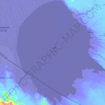
Name: Lake Assal topographic map, elevation, terrain.
Location: Lake Assal, Balho, Tadjourah, Djibouti (11.60503 42.37719 11.70638 42.46404)
Average elevation: -133 m
Minimum elevation: -158 m
Maximum elevation: 213 m