Geolocate

Rajouri topographic map

Click on the map to display elevation.

Rajouri

Rajouri is located at 33°23′N 74°18′E / 33.38°N 74.3°E / 33.38; 74.3. It has an average elevation of 915 metres (3001 feet).

Wikipedia (CC-BY-SA 3.0)

About this map

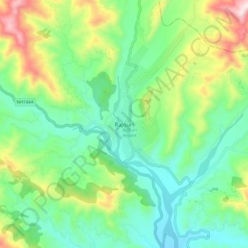
Name: Rajouri topographic map, elevation, terrain.

Location: Rajouri, Rajauri, Rajouri District, Jammu and Kashmir, 185131, India (33.33725 74.27323 33.41725 74.35323)

Average elevation: 1,038 m

Minimum elevation: 829 m

Maximum elevation: 1,511 m

Gear up for your next adventure:

🗺️Ordnance Survey Maps - Official UK maps for walking and outdoor activities
👕Merino Base Layers - Natural temperature regulation for cold weather hiking and camping
🕶️Glacier Goggles - Maximum protection for high-altitude snow topography
🦶Anti-Blister Balms - Protect your feet before long topographic expeditions
📻Hand-Crank Emergency Radios - Stay updated on weather warnings in remote areas

As an Amazon Associate, this site earns from qualifying purchases at no extra cost to you.