
Lamagdelaine topographic map
Interactive map
Click on the map to display elevation.
About this map
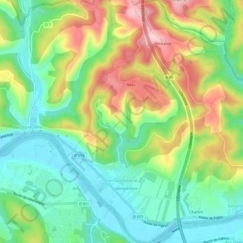
Name: Lamagdelaine topographic map, elevation, terrain.
Average elevation: 198 m
Minimum elevation: 113 m
Maximum elevation: 334 m
Other topographic maps
Click on a map to view its topography, its elevation and its terrain.
Saint-Daunès
Francia > Occitania > Lot > Barguelonne-en-Quercy
Saint-Daunès, Barguelonne-en-Quercy, Cahors, Lot, Occitania, Francia metropolitana, 46800, Francia
Average elevation: 219 m
Rocamadour
Rocamadour, Gourdon, Lot, Occitania, Francia metropolitana, 46500, Francia
Average elevation: 247 m