
Ströbitz topographic map
Interactive map
Click on the map to display elevation.
About this map
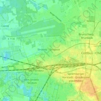
Name: Ströbitz topographic map, elevation, terrain.
Location: Ströbitz, Cottbus, Brandenburg, 03046, Deutschland (51.73403 14.27508 51.78168 14.32929)
Average elevation: 71 m
Minimum elevation: 59 m
Maximum elevation: 85 m
Other topographic maps
Click on a map to view its topography, its elevation and its terrain.
Cottbus
Deutschland > Brandenburg > Cottbus
Cottbus, Brandenburg, 03046, Deutschland
Average elevation: 79 m
Hermannsberg
Deutschland > Brandenburg > Cottbus
Hermannsberg, Cottbus, Brandenburg, 03042, Deutschland
Average elevation: 76 m
Saspow
Deutschland > Brandenburg > Cottbus
Saspow, Cottbus, Brandenburg, Deutschland
Average elevation: 68 m
Kiekebusch
Deutschland > Brandenburg > Cottbus > Kiekebusch
Kiekebusch, Cottbus, Brandenburg, 03051, Deutschland
Average elevation: 80 m
Madlow
Deutschland > Brandenburg > Cottbus > Madlow
Madlow, Cottbus, Brandenburg, 03050, Deutschland
Average elevation: 81 m