
Thakkolam topographic map
Interactive map
Click on the map to display elevation.
About this map
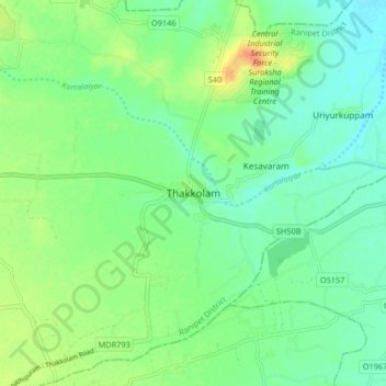
Name: Thakkolam topographic map, elevation, terrain.
Average elevation: 75 m
Minimum elevation: 61 m
Maximum elevation: 101 m
Other topographic maps
Click on a map to view its topography, its elevation and its terrain.
Arakkonam
India > Tamil Nadu > Arakonam
Arakkonam, Arakonam, Ranipet District, Tamil Nadu, 631001, India
Average elevation: 88 m
Banavaram
India > Tamil Nadu > Arakonam
Banavaram, Arakonam, Ranipet District, Tamil Nadu, 632505, India
Average elevation: 126 m