
Ecoteaux topographic map
Interactive map
Click on the map to display elevation.
About this map
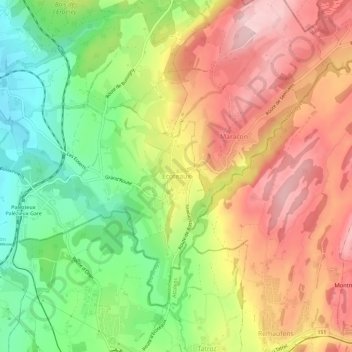
Name: Ecoteaux topographic map, elevation, terrain.
Location: Ecoteaux, Oron, District de Lavaux-Oron, Vaud, 1612, Suisse (46.52551 6.84324 46.56551 6.88324)
Average elevation: 759 m
Minimum elevation: 630 m
Maximum elevation: 884 m
Other topographic maps
Click on a map to view its topography, its elevation and its terrain.
Château d'Oron
Suisse > Vaud > District de Lavaux-Oron > Oron
Château d'Oron, 1, Au Château, Oron-le-Châtel, Oron, District de Lavaux-Oron, Vaud, 1608, Suisse
Average elevation: 701 m