Geolocate

Kartasura topographic map

Interactive map

Click on the map to display elevation.

About this map

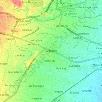
Name: Kartasura topographic map, elevation, terrain.

Location: Kartasura, Sukoharjo, Central Java, Java, 57165, Indonesia (-7.59213 110.70053 -7.51213 110.78053)

Average elevation: 126 m

Minimum elevation: 101 m

Maximum elevation: 172 m

Other topographic maps

Click on a map to view its topography, its elevation and its terrain.

Bulu

Indonesia > Central Java > Sukoharjo

Average elevation: 126 m

Puron

Indonesia > Central Java > Sukoharjo

Average elevation: 128 m

Lapangan Makamhaji

Indonesia > Central Java > Sukoharjo > Gentan > Kuyudan

Average elevation: 104 m

Waduk Mulur

Indonesia > Central Java > Sukoharjo > Bendosari

Average elevation: 114 m

Karangasem

Indonesia > Central Java > Sukoharjo > Karangasem

Average elevation: 115 m