Geolocate

Moledo topographic map

Click on the map to display elevation.

About this map
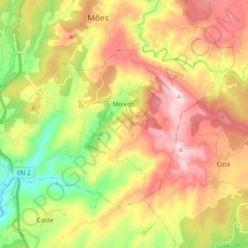
Name: Moledo topographic map, elevation, terrain.

Location: Moledo, Castro Daire, Viseu, Portugal (40.78672 -7.94499 40.85484 -7.81108)

Average elevation: 602 m

Minimum elevation: 302 m

Maximum elevation: 921 m

Other topographic maps

Click on a map to view its topography, its elevation and its terrain.

Cotelo

Portugal > Viseu > Castro Daire > Gosende

Average elevation: 1,059 m

Levadas

Portugal > Viseu > Castro Daire > Cabril

Average elevation: 813 m

Gear up for your next adventure:

🧼Biodegradable Soap - Leave-no-trace hygiene for multi-day mountain treks
🕶️Polarized Sunglasses - Reduces glare from snow and water when reading terrain
🗺️Ordnance Survey Maps - Official UK maps for walking and outdoor activities
📷Outdoor Action Cameras - Cameras designed for hiking and adventure
📸Action Camera Chest Mounts - Record your ascent following topographic paths hands-free

As an Amazon Associate, this site earns from qualifying purchases at no extra cost to you.