
Sandia Park topographic map
Interactive map
Click on the map to display elevation.
About this map
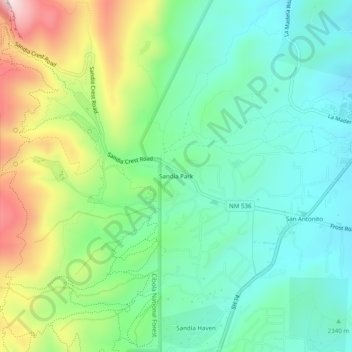
Name: Sandia Park topographic map, elevation, terrain.
Average elevation: 2,198 m
Minimum elevation: 2,054 m
Maximum elevation: 2,513 m
Other topographic maps
Click on a map to view its topography, its elevation and its terrain.
Albuquerque
United States > New Mexico > Bernalillo County
Albuquerque features a striking topography characterized by its elevation and diverse geological formations. The city sits at an approximate elevation of 4,900 feet (1,500 meters) near the Rio Grande, rising dramatically to over 6,700 feet (2,000 meters) in the foothills of the nearby Sandia Mountains. These…
Average elevation: 1,687 m
Albuquerque
United States > New Mexico > Bernalillo County
Located in north-central New Mexico, Albuquerque serves as the county seat of Bernalillo County. To its east are the Sandia–Manzano Mountains, Rio Grande flows north to south through its center, while the West Mesa and Petroglyph National Monument make up the western part of the city. Albuquerque has one of…
Average elevation: 1,687 m
Albuquerque
United States > New Mexico > Bernalillo County
Albuquerque is located in north-central New Mexico. To its east are the Sandia–Manzano Mountains. The Rio Grande flows north to south through its center, while the West Mesa and Petroglyph National Monument make up the western part of the city. Albuquerque has one of the highest elevations of any major city…
Average elevation: 1,688 m
Joe M. Lucero Hillside
United States > New Mexico > Bernalillo County > Albuquerque
Average elevation: 1,637 m
Albuquerque
United States > New Mexico > Bernalillo County
Albuquerque serves as the county seat of Bernalillo County, and is in north-central New Mexico. The Sandia Mountains run along the eastern side of Albuquerque, and the Rio Grande flows north to south through its center, while the West Mesa and Petroglyph National Monument make up the western part of the city.…
Average elevation: 1,687 m
Albuquerque
United States > New Mexico > Bernalillo County
Albuquerque serves as the county seat of Bernalillo County, and is in north-central New Mexico. The Sandia Mountains run along the eastern side of Albuquerque, and the Rio Grande flows through the city. Albuquerque has one of the highest elevations of any major city in the U.S., ranging from 4,900 feet (1,490…
Average elevation: 1,687 m