
Make a donation
Gear up for your next adventure:
As an Amazon Associate, this site earns from qualifying purchases at no extra cost to you.
Cap Bénat topographic map
Click on the map to display elevation.
Make a donation
Gear up for your next adventure:
As an Amazon Associate, this site earns from qualifying purchases at no extra cost to you.
About this map
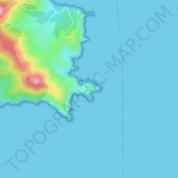
Name: Cap Bénat topographic map, elevation, terrain.
Average elevation: 17 m
Minimum elevation: 0 m
Maximum elevation: 176 m
Make a donation
Gear up for your next adventure:
As an Amazon Associate, this site earns from qualifying purchases at no extra cost to you.
Other topographic maps
Click on a map to view its topography, its elevation and its terrain.
83230
France > Provence-Alpes-Côte d'Azur > Var > Bormes-les-Mimosas > Manjastre
Average elevation: 151 m
Château de Bénat
France > Provence-Alpes-Côte d'Azur > Var > Bormes-les-Mimosas
Average elevation: 55 m
Fort de Brégançon
France > Provence-Alpes-Côte d'Azur > Var > Bormes-les-Mimosas
Il est situé au bord de la Méditerranée, sur le territoire de la commune de Bormes-les-Mimosas (Var), sur le haut d'un piton rocheux de 35 mètres d'altitude et à quelques mètres de la côte du cap Bénat. La construction d'une jetée artificielle fut ordonnée par le général de Gaulle (à l'origine, il…
Average elevation: 8 m