
Ngongotahā topographic map
Interactive map
Click on the map to display elevation.
About this map
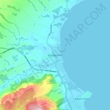
Name: Ngongotahā topographic map, elevation, terrain.
Average elevation: 339 m
Minimum elevation: 281 m
Maximum elevation: 732 m
Other topographic maps
Click on a map to view its topography, its elevation and its terrain.
Lake Ōkareka
New Zealand > Bay of Plenty > Rotorua Lakes District > Lake Okareka
Average elevation: 392 m
Lake Ōkareka
New Zealand > Bay of Plenty > Rotorua Lakes District > Lake Okareka
Average elevation: 392 m
Lake Ōkareka
New Zealand > Bay of Plenty > Rotorua Lakes District > Lake Okareka
Average elevation: 392 m