
Make a donation
Gear up for your next adventure:
As an Amazon Associate, this site earns from qualifying purchases at no extra cost to you.
Rufat topographic map
Click on the map to display elevation.
Make a donation
Gear up for your next adventure:
As an Amazon Associate, this site earns from qualifying purchases at no extra cost to you.
About this map
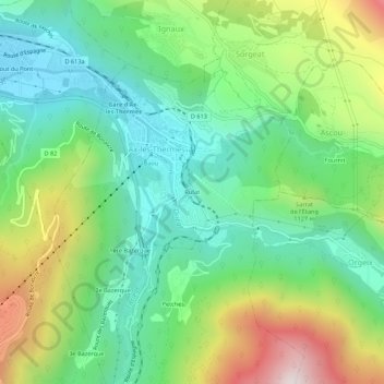
Name: Rufat topographic map, elevation, terrain.
Average elevation: 994 m
Minimum elevation: 675 m
Maximum elevation: 1,627 m
Make a donation
Gear up for your next adventure:
As an Amazon Associate, this site earns from qualifying purchases at no extra cost to you.
Other topographic maps
Click on a map to view its topography, its elevation and its terrain.
Ax-les-Thermes
France > Occitania > Ariège > Ax-les-Thermes
Ax (from Latin Aquae – water; French Thermes – hot springs), situated at an elevation of 700 metres (2,300 ft), is well known for its sulphurous hot springs (25 to 78 °C or 77 to 172 °F). The waters, which were used by the Romans, were historically claimed to treat rheumatism, skin diseases, and other…
Average elevation: 1,449 m