
Make a donation
Gear up for your next adventure:
As an Amazon Associate, this site earns from qualifying purchases at no extra cost to you.
Kazerun topographic map
Click on the map to display elevation.
Make a donation
Gear up for your next adventure:
As an Amazon Associate, this site earns from qualifying purchases at no extra cost to you.
Kazerun
Shapur Cave is located at an altitude of 800 meters above the ground and the statue of Shapur I, the Sassanid king, is located at a height of 7 meters at its entrance. This statue is considered the biggest statue of ancient Iran. Shapur cave is also included in the list of world Heritage Sites.
Make a donation
Gear up for your next adventure:
As an Amazon Associate, this site earns from qualifying purchases at no extra cost to you.
About this map
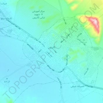
Name: Kazerun topographic map, elevation, terrain.
Average elevation: 868 m
Minimum elevation: 808 m
Maximum elevation: 1,332 m
Make a donation
Gear up for your next adventure:
As an Amazon Associate, this site earns from qualifying purchases at no extra cost to you.
Other topographic maps
Click on a map to view its topography, its elevation and its terrain.