
Thank you for supporting this site ❤️
Make a donation
Make a donation
Gear up for your next adventure:
As an Amazon Associate, this site earns from qualifying purchases at no extra cost to you.
Dzongri topographic map
Click on the map to display elevation.
Thank you for supporting this site ❤️
Make a donation
Make a donation
Gear up for your next adventure:
As an Amazon Associate, this site earns from qualifying purchases at no extra cost to you.
About this map
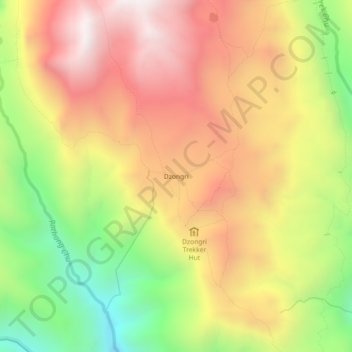
Name: Dzongri topographic map, elevation, terrain.
Location: Dzongri, Gyalshing, Gyalshing District, Sikkim, India (27.46169 88.13800 27.50169 88.17800)
Average elevation: 3,859 m
Minimum elevation: 3,150 m
Maximum elevation: 4,474 m
Thank you for supporting this site ❤️
Make a donation
Make a donation
Gear up for your next adventure:
As an Amazon Associate, this site earns from qualifying purchases at no extra cost to you.