
Faizabad topographic map
Interactive map
Click on the map to display elevation.
About this map
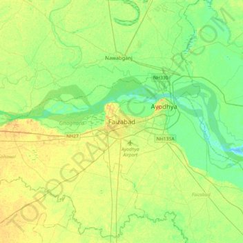
Name: Faizabad topographic map, elevation, terrain.
Location: Faizabad, Ayodhya District, Uttar Pradesh, 224001, India (26.61893 81.98269 26.93893 82.30269)
Average elevation: 97 m
Minimum elevation: 86 m
Maximum elevation: 110 m
Other topographic maps
Click on a map to view its topography, its elevation and its terrain.
Ayodhya
India > Uttar Pradesh > Faizabad
The earliest of the Buddhist Pali-language texts and the Jain Prakrit-language texts mention a city called Saketa (Sageya or Saeya in Prakrit) as an important city of the Kosala mahajanapada. Topographical indications in both Buddhist and Jain texts suggest that Saketa is the same as the present-day Ayodhya.…
Average elevation: 96 m