
Lockwood Valley topographic map
Interactive map
Click on the map to display elevation.
About this map
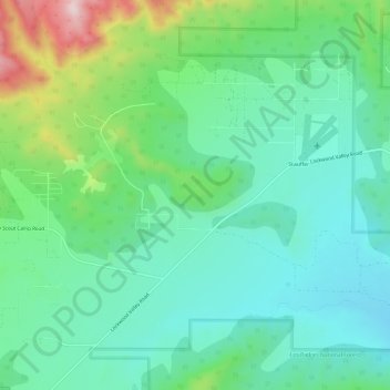
Name: Lockwood Valley topographic map, elevation, terrain.
Location: Lockwood Valley, Ventura County, California, United States (34.73916 -119.12008 34.76182 -119.06055)
Average elevation: 1,602 m
Minimum elevation: 1,489 m
Maximum elevation: 1,916 m
Other topographic maps
Click on a map to view its topography, its elevation and its terrain.
Ojai
United States > California > Ventura County
Nordhoff Ridge, the western extension of the Topatopa Mountains, towers over the north side of the valley at more than 5,000 feet (1,500 m). Sulphur Mountain creates the southern ranges bounding the Ojai Valley, a little under 3,000 feet (910 m) in elevation. The Sulphur and Topatopa mountains are part of the…
Average elevation: 289 m
Wildwood Park
United States > California > Ventura County > Thousand Oaks
At Lizard Rock, Teepee Overlook, and similar higher elevation areas, there are panoramic views of the Conejo Valley.
Average elevation: 161 m
Jasmine Glen Estates
United States > California > Ventura County > Simi Valley
Average elevation: 331 m
Thousand Oaks
United States > California > Ventura County
The northern parts consist of mountainous terrain in the Simi Hills, Conejo Mountains and Mount Clef Ridge. Narrow canyons such as Hill Canyon cut through the steeper mountainous areas. Conejo Mountain and Conejo Grade are found in westernmost Newbury Park, while the southernmost parts of Thousand Oaks are…
Average elevation: 333 m
Newbury Park
United States > California > Ventura County > Thousand Oaks > Newbury Park
Newbury Park can be described as a town, community, or section mostly within the Thousand Oaks city limits in addition to rural areas west of Thousand Oaks. Newbury Park is bordered by Lynn Road in the east and the Conejo Grade on the west. It borders the Santa Monica Mountains in the south, while Hill Canyon…
Average elevation: 262 m
Simi Valley
United States > California > Ventura County
Simi Valley is a city located in the very southeast corner of Ventura County, bordering the San Fernando Valley in Los Angeles County, and is a part of the Greater Los Angeles Area. The city of Simi Valley basically consists of the eponymous valley itself. The city of Simi Valley borders the Santa Susana…
Average elevation: 405 m
Santa Paula
United States > California > Ventura County
On October 31, 2019, the Maria Fire was reported burning at the top of South Mountain between Santa Paula and Somis and expanded throughout that evening. Heavily influenced by 20–30 mph (32–48 km/h) winds within the canyons, the fire became a full scale conflagration, growing from 50 to 750 acres (20 to…
Average elevation: 148 m
Casitas Springs
United States > California > Ventura County > Ventura > Casitas Springs
Average elevation: 182 m
Greenwich Village
United States > California > Ventura County > Thousand Oaks > Greenwich Village
Average elevation: 275 m
Johnson Creek Park
United States > California > Ventura County > Oxnard > Pleasant Valley Mobile Home Park
Average elevation: 10 m
Camarillo
United States > California > Ventura County
In the mid-1950s, the Ventura Freeway, which bisects the town, was completed from Los Angeles to points north, making it an easy one-hour trip to Camarillo. The freeway was originally planned to follow the path of Potrero Road, south of Camarillo, which would have completely by-passed the soon-to-be city.…
Average elevation: 90 m