Geolocate

Plainfield topographic map

Interactive map

Click on the map to display elevation.

About this map

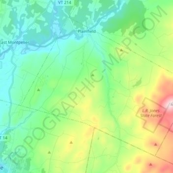
Name: Plainfield topographic map, elevation, terrain.

Location: Plainfield, Washington County, Vermont, 05667, United States (44.20389 -72.48022 44.28632 -72.33687)

Average elevation: 388 m

Minimum elevation: 194 m

Maximum elevation: 905 m

Other topographic maps

Click on a map to view its topography, its elevation and its terrain.

East Calais

United States > Vermont > Washington County > Calais

Average elevation: 336 m

Duxbury

United States > Vermont > Washington County

Average elevation: 335 m

Barre City

United States > Vermont > Washington County

Average elevation: 262 m

Montpelier

United States > Vermont > Washington County

Montpelier is located in the north-central area of Vermont. The city center is a flat clay zone (elevation 520 ft; 160 m), surrounded by hills and granite ledges. Towne Hill runs in a 2-mile (3.2 km) ridge (~900 ft; 270 m) along the northern edge of the city.

Average elevation: 284 m

Waitsfield

United States > Vermont > Washington County

Average elevation: 424 m

Waterbury

United States > Vermont > Washington County > Waterbury

Average elevation: 199 m

Worcester

United States > Vermont > Washington County

Average elevation: 461 m

Fayston

United States > Vermont > Washington County

Average elevation: 504 m

Middlesex

United States > Vermont > Washington County > Middlesex

Average elevation: 330 m

Calais

United States > Vermont > Washington County

Average elevation: 363 m