
Thank you for supporting this site ❤️
Make a donation
Make a donation
Gear up for your next adventure:
As an Amazon Associate, this site earns from qualifying purchases at no extra cost to you.
Kalwa topographic map
Click on the map to display elevation.
Thank you for supporting this site ❤️
Make a donation
Make a donation
Gear up for your next adventure:
As an Amazon Associate, this site earns from qualifying purchases at no extra cost to you.
About this map
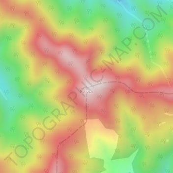
Name: Kalwa topographic map, elevation, terrain.
Location: Kalwa, Dunda, Uttarkashi District, Uttarakhand, India (30.61420 78.44660 30.61430 78.44670)
Average elevation: 2,205 m
Minimum elevation: 1,844 m
Maximum elevation: 2,521 m
Thank you for supporting this site ❤️
Make a donation
Make a donation
Gear up for your next adventure:
As an Amazon Associate, this site earns from qualifying purchases at no extra cost to you.