
Make a donation
Gear up for your next adventure:
As an Amazon Associate, this site earns from qualifying purchases at no extra cost to you.
Mymensingh topographic map
Click on the map to display elevation.
Make a donation
Gear up for your next adventure:
As an Amazon Associate, this site earns from qualifying purchases at no extra cost to you.
Mymensingh
The city was constituted by the British East India Company on 1 May 1787. According to Ministry of Public Administration, Mymensingh is ranked 4th in district status. The population density of Mymensingh city is 44,458/km2 (115,150/sq mi), making it the second most densely populated city in Bangladesh. Mymensingh attracts 25 percent of all the health tourists visiting Bangladesh. Mymensingh is an anglicization of the name Momen Singh, referring to a Muslim ruler called Shah Momin or Momin Singh, an ethnic Bengali Muslim ruler. Its elevation is over 19 m above sea level, the highest of Bangladesh's major cities. Mymensingh is close to Tura, a city in Meghalaya from the Gobrakura Land Port.
Make a donation
Gear up for your next adventure:
As an Amazon Associate, this site earns from qualifying purchases at no extra cost to you.
About this map
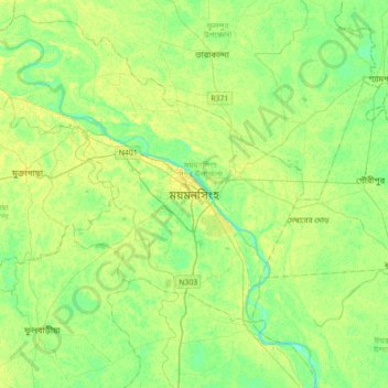
Name: Mymensingh topographic map, elevation, terrain.
Average elevation: 14 m
Minimum elevation: 5 m
Maximum elevation: 22 m
Make a donation
Gear up for your next adventure:
As an Amazon Associate, this site earns from qualifying purchases at no extra cost to you.
Other topographic maps
Click on a map to view its topography, its elevation and its terrain.
BINA pond
Bangladesh > Mymensingh Division > Mymensingh Sadar Upazila > Mymensingh
Average elevation: 15 m