
Lorton topographic map
Interactive map
Click on the map to display elevation.
Lorton
According to the United States Census Bureau, the Lorton CDP has a total area of 5.4 square miles (13.9 km2), of which 5.3 square miles (13.7 km2) is land and 0.1 square miles (0.2 km2), or 1.39%, is water. The elevation ranges from sea level at the Prince William County line (the Occoquan River) to slightly over 200 feet (61 m) along Furnace Road at the CDP's western edge.
About this map
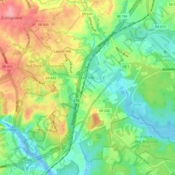
Name: Lorton topographic map, elevation, terrain.
Location: Lorton, Fairfax County, Virginia, United States (38.66687 -77.28193 38.73371 -77.19295)
Average elevation: 41 m
Minimum elevation: -4 m
Maximum elevation: 107 m
Other topographic maps
Click on a map to view its topography, its elevation and its terrain.
Izaak Walton League of America - Arlington-Fairfax Chapter
United States > Virginia > Fairfax County > Centreville
Average elevation: 72 m
George Washington's Mount Vernon
United States > Virginia > Fairfax County > Mount Vernon
Visitors to Mount Vernon now see Washington's study, a room to which in the 18th century only a privileged few were granted entry. This simply furnished room has a combined bathroom, dressing room and office; the room was so private that few contemporary descriptions exist. Its walls are lined with naturally…
Average elevation: 14 m
Mount Vernon Community Park
United States > Virginia > Fairfax County > Fort Hunt > Snowden
Average elevation: 14 m
Shirley Gate Park
United States > Virginia > Fairfax County > George Mason > Shirley Gate Park
Average elevation: 128 m