
Old Mill Estates topographic map
Interactive map
Click on the map to display elevation.
About this map
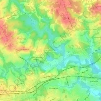
Name: Old Mill Estates topographic map, elevation, terrain.
Average elevation: 287 m
Minimum elevation: 253 m
Maximum elevation: 325 m
Other topographic maps
Click on a map to view its topography, its elevation and its terrain.
Mountain Bridge Wilderness Area
United States > South Carolina > Greenville County
Average elevation: 680 m
Piney Ridge
United States > South Carolina > Greenville County > Wade Hampton
Average elevation: 304 m
Orchard Acres
United States > South Carolina > Greenville County > Wade Hampton
Average elevation: 292 m
Glenwood Acres
United States > South Carolina > Greenville County > Greenville
Average elevation: 305 m
Simpsonville
United States > South Carolina > Greenville County
Simpsonville is located in southeastern Greenville County at 34°44′0″N 82°15′36″W / 34.73333°N 82.26000°W / 34.73333; -82.26000 (34.733375, -82.260001), between Mauldin to the northwest and Fountain Inn to the southeast. The center of town has an elevation of 866 feet (264 m) above sea level.
Average elevation: 258 m
Bald Rock Heritage Preserve
United States > South Carolina > Greenville County
Average elevation: 480 m