
Cold Spring topographic map
Interactive map
Click on the map to display elevation.
About this map
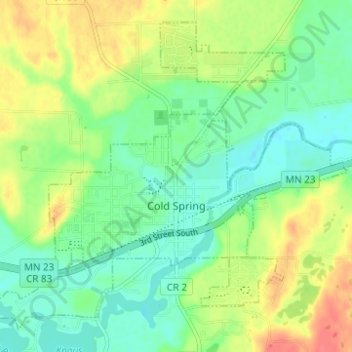
Name: Cold Spring topographic map, elevation, terrain.
Location: Cold Spring, Stearns County, Minnesota, 56320, United States (45.44041 -94.46056 45.47844 -94.39871)
Average elevation: 349 m
Minimum elevation: 327 m
Maximum elevation: 383 m
Other topographic maps
Click on a map to view its topography, its elevation and its terrain.
St. Cloud
United States > Minnesota > Stearns County
St. Cloud, Stearns County, Minnesota, United States
Average elevation: 319 m
Avon Beach
United States > Minnesota > Stearns County > Avon
Avon Beach, Avon, Stearns County, Minnesota, 56310, United States
Average elevation: 344 m
Farming
United States > Minnesota > Stearns County
Farming, Stearns County, Minnesota, United States
Average elevation: 362 m