Geolocate

Liang topographic map

Click on the map to display elevation.

About this map

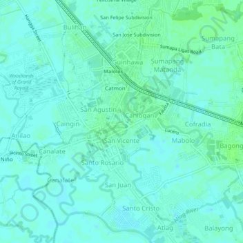
Name: Liang topographic map, elevation, terrain.

Location: Liang, Bulacan, Central Luzon, 3000, Philippines (14.82583 120.79472 14.86583 120.83472)

Average elevation: 4 m

Minimum elevation: 1 m

Maximum elevation: 8 m

Other topographic maps

Click on a map to view its topography, its elevation and its terrain.

Hagonoy

Philippines > Bulacan

Average elevation: 1 m

Sapang Pare

Philippines > Bulacan > Santo Cristo

Average elevation: 4 m

Bulakan

Philippines > Bulacan > Bulakan

Average elevation: 4 m

Meycauayan

Philippines > Bulacan

Average elevation: 14 m

Doña Remedios Trinidad

Philippines > Bulacan

List of highest peaks in D.R.T by elevation.

Average elevation: 172 m

Gear up for your next adventure:

Altimeter Watches - Watches measuring altitude for mountain activities
📍Handheld GPS Navigators - Reliable satellite navigation for hiking and off-road exploration
Lightweight Solo Tents - Backpacking tents designed for wild camping in the UK highlands
🥄Titanium Camping Sporks - The ultimate lightweight utensil for trail meals
📷Outdoor Action Cameras - Cameras designed for hiking and adventure

As an Amazon Associate, this site earns from qualifying purchases at no extra cost to you.