
Make a donation
Gear up for your next adventure:
As an Amazon Associate, this site earns from qualifying purchases at no extra cost to you.
Fayetteville topographic map
Click on the map to display elevation.
Make a donation
Gear up for your next adventure:
As an Amazon Associate, this site earns from qualifying purchases at no extra cost to you.
About this map
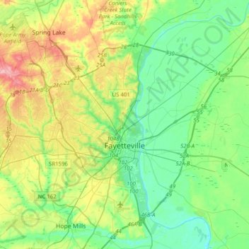
Name: Fayetteville topographic map, elevation, terrain.
Average elevation: 48 m
Minimum elevation: 12 m
Maximum elevation: 128 m
Make a donation
Gear up for your next adventure:
As an Amazon Associate, this site earns from qualifying purchases at no extra cost to you.
Other topographic maps
Click on a map to view its topography, its elevation and its terrain.
Vanstory Hills
United States > North Carolina > Cumberland County > Fayetteville
Average elevation: 63 m
Blounts Creek
United States > North Carolina > Cumberland County > Fayetteville
Average elevation: 29 m
Make a donation
Gear up for your next adventure:
As an Amazon Associate, this site earns from qualifying purchases at no extra cost to you.
Loch Lommond
United States > North Carolina > Cumberland County > Fayetteville
Average elevation: 70 m
Make a donation
Gear up for your next adventure:
As an Amazon Associate, this site earns from qualifying purchases at no extra cost to you.
Eaglewood Forest
United States > North Carolina > Cumberland County > Hope Mills
Average elevation: 45 m
Make a donation
Gear up for your next adventure:
As an Amazon Associate, this site earns from qualifying purchases at no extra cost to you.
Williams Village
United States > North Carolina > Cumberland County > Fayetteville
Average elevation: 30 m