
Make a donation
Gear up for your next adventure:
As an Amazon Associate, this site earns from qualifying purchases at no extra cost to you.
Fort Meade topographic map
Click on the map to display elevation.
Make a donation
Gear up for your next adventure:
As an Amazon Associate, this site earns from qualifying purchases at no extra cost to you.
Fort Meade
Fort Meade is the oldest city in Polk County, dating its origins to 1849 when it was established along a new military road from Tampa (Fort Brooke) to Fort Pierce following the Second Seminole War. The town and road were originally sited by then-lieutenant George Meade of the Corps of Topographical Engineers, whose commander named it for him. Around the start of the American Civil War a mounted volunteer company nicknamed the "Hickory Boys" was formed at the fort. The 1880s business district was located on old Wire Street (now Broadway), which was a casualty of four devastating fires. Today, there are over 150 buildings which are designated as landmarks. In the 1890s the Fort Meade Street Railway operated a horse-drawn service in the town.
Make a donation
Gear up for your next adventure:
As an Amazon Associate, this site earns from qualifying purchases at no extra cost to you.
About this map
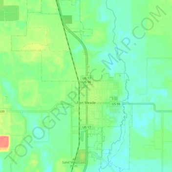
Name: Fort Meade topographic map, elevation, terrain.
Location: Fort Meade, Polk County, Florida, 33861, United States (27.71892 -81.84238 27.80140 -81.77697)
Average elevation: 39 m
Minimum elevation: 19 m
Maximum elevation: 86 m
Make a donation
Gear up for your next adventure:
As an Amazon Associate, this site earns from qualifying purchases at no extra cost to you.
Other topographic maps
Click on a map to view its topography, its elevation and its terrain.
Allen David Broussard Catfish Creek Preserve State Park
United States > Florida > Polk County
Average elevation: 18 m
Make a donation
Gear up for your next adventure:
As an Amazon Associate, this site earns from qualifying purchases at no extra cost to you.
Make a donation
Gear up for your next adventure:
As an Amazon Associate, this site earns from qualifying purchases at no extra cost to you.
Make a donation
Gear up for your next adventure:
As an Amazon Associate, this site earns from qualifying purchases at no extra cost to you.
Make a donation
Gear up for your next adventure:
As an Amazon Associate, this site earns from qualifying purchases at no extra cost to you.
Make a donation
Gear up for your next adventure:
As an Amazon Associate, this site earns from qualifying purchases at no extra cost to you.
Make a donation
Gear up for your next adventure:
As an Amazon Associate, this site earns from qualifying purchases at no extra cost to you.
Make a donation
Gear up for your next adventure:
As an Amazon Associate, this site earns from qualifying purchases at no extra cost to you.
Make a donation
Gear up for your next adventure:
As an Amazon Associate, this site earns from qualifying purchases at no extra cost to you.