
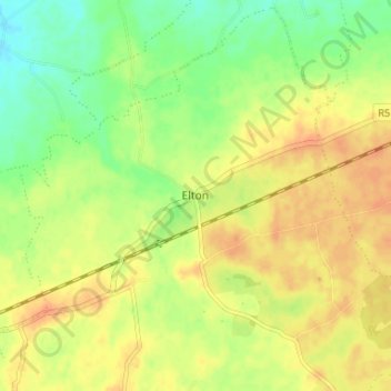
Elton topographic map
Interactive map
Click on the map to display elevation.
About this map
Name: Elton topographic map, elevation, terrain.
Average elevation: 104 m
Minimum elevation: 84 m
Maximum elevation: 119 m
Other topographic maps
Click on a map to view its topography, its elevation and its terrain.
Coolnahila (Palmer)
Ireland > County Limerick > The Municipal District of Cappamore — Kilmallock
Average elevation: 39 m
Curraghafoil
Ireland > County Limerick > The Municipal District of Cappamore — Kilmallock
Average elevation: 245 m
Ardroe
Ireland > County Limerick > The Municipal District of Cappamore — Kilmallock
Average elevation: 102 m
Lough Gur
Ireland > County Limerick > The Municipal District of Cappamore — Kilmallock
Average elevation: 84 m
Balline
Ireland > County Limerick > The Municipal District of Cappamore — Kilmallock
Average elevation: 109 m
Kilduff
Ireland > County Limerick > The Municipal District of Cappamore — Kilmallock
Average elevation: 80 m
Bilboa
Ireland > County Limerick > The Municipal District of Cappamore — Kilmallock
Average elevation: 88 m