
Norwood topographic map
Interactive map
Click on the map to display elevation.
About this map
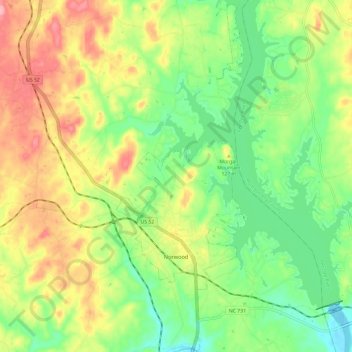
Name: Norwood topographic map, elevation, terrain.
Location: Norwood, Stanly County, North Carolina, United States (35.19335 -80.16604 35.29014 -80.09509)
Average elevation: 112 m
Minimum elevation: 62 m
Maximum elevation: 177 m
Other topographic maps
Click on a map to view its topography, its elevation and its terrain.
Forest Drive
United States > North Carolina > Stanly County > Albemarle > Forest Drive
Average elevation: 166 m