
Make a donation
Gear up for your next adventure:
As an Amazon Associate, this site earns from qualifying purchases at no extra cost to you.
Cornetu topographic map
Click on the map to display elevation.
Make a donation
Gear up for your next adventure:
As an Amazon Associate, this site earns from qualifying purchases at no extra cost to you.
About this map
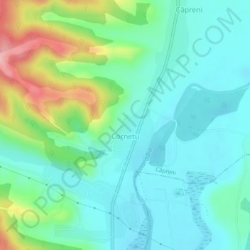
Name: Cornetu topographic map, elevation, terrain.
Location: Cornetu, Căpreni, Gorj, Romania (44.73608 23.61605 44.74274 23.62555)
Average elevation: 236 m
Minimum elevation: 195 m
Maximum elevation: 353 m
Make a donation
Gear up for your next adventure:
As an Amazon Associate, this site earns from qualifying purchases at no extra cost to you.
Other topographic maps
Click on a map to view its topography, its elevation and its terrain.
Make a donation
Gear up for your next adventure:
As an Amazon Associate, this site earns from qualifying purchases at no extra cost to you.
Make a donation
Gear up for your next adventure:
As an Amazon Associate, this site earns from qualifying purchases at no extra cost to you.
Make a donation
Gear up for your next adventure:
As an Amazon Associate, this site earns from qualifying purchases at no extra cost to you.
Novaci
Only 12 km (7.5 mi) from Novaci, passing the Transalpina (DN67C) road is Rânca (1,600 m (5,200 ft) altitude), a newly developed resort surrounded by mountain peaks and tremendous beauty. From this place is a view of the Parângu Mare peak and when the weather is good you can see the Peleaga peak of the…
Average elevation: 1,056 m
Make a donation
Gear up for your next adventure:
As an Amazon Associate, this site earns from qualifying purchases at no extra cost to you.