
Rome topographic map
Interactive map
Click on the map to display elevation.
About this map
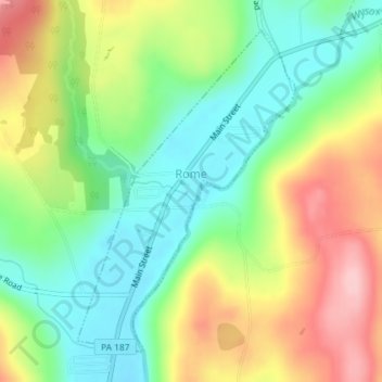
Name: Rome topographic map, elevation, terrain.
Location: Rome, Bradford County, Pennsylvania, United States (41.84581 -76.35160 41.86860 -76.33084)
Average elevation: 314 m
Minimum elevation: 242 m
Maximum elevation: 416 m
Other topographic maps
Click on a map to view its topography, its elevation and its terrain.
Gillett
United States > Pennsylvania > Bradford County > South Creek Township
Average elevation: 470 m
Ridgebury
United States > Pennsylvania > Bradford County > Ridgebury Township
Average elevation: 394 m
Stevensville
United States > Pennsylvania > Bradford County > Stevens Township
Average elevation: 328 m
Allis Hollow
United States > Pennsylvania > Bradford County > Orwell Township
Average elevation: 348 m