
Make a donation
Gear up for your next adventure:
As an Amazon Associate, this site earns from qualifying purchases at no extra cost to you.
Crackpot topographic map
Click on the map to display elevation.
Make a donation
Gear up for your next adventure:
As an Amazon Associate, this site earns from qualifying purchases at no extra cost to you.
About this map
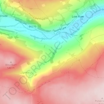
Name: Crackpot topographic map, elevation, terrain.
Average elevation: 387 m
Minimum elevation: 191 m
Maximum elevation: 560 m
North Yorkshire trails, hiking, mountain biking, running and outdoor activities
Make a donation
Gear up for your next adventure:
As an Amazon Associate, this site earns from qualifying purchases at no extra cost to you.
Other topographic maps
Click on a map to view its topography, its elevation and its terrain.
Harrogate
United Kingdom > England > North Yorkshire
Harrogate is situated on the edge of the Yorkshire Dales, with the Vale of York to the east and the upland Yorkshire Dales to the west and north-west. It has a dry and mild climate, typical of places in the rain shadow of the Pennines. It is on the A59 from Skipton to York. At an altitude of between 100 and…
Average elevation: 131 m
Make a donation
Gear up for your next adventure:
As an Amazon Associate, this site earns from qualifying purchases at no extra cost to you.
North York Moors National Park
United Kingdom > England > North Yorkshire
As part of the United Kingdom, the North York Moors area generally has warm summers and relatively mild winters. Weather conditions vary from day to day as well as from season to season. The latitude of the area means that it is influenced by predominantly westerly winds with depressions and their associated…
Average elevation: 110 m
Make a donation
Gear up for your next adventure:
As an Amazon Associate, this site earns from qualifying purchases at no extra cost to you.
Scarborough
United Kingdom > England > North Yorkshire
The climate is temperate with mild summers and cool, windy, winters. The hottest months of the year are July and August, with temperatures reaching an average high of 17 °C and falling to 11 °C at night. The average daytime temperatures in January are 4 °C, falling to 1 °C at night. The station's elevation…
Average elevation: 50 m
Make a donation
Gear up for your next adventure:
As an Amazon Associate, this site earns from qualifying purchases at no extra cost to you.
Make a donation
Gear up for your next adventure:
As an Amazon Associate, this site earns from qualifying purchases at no extra cost to you.
Make a donation
Gear up for your next adventure:
As an Amazon Associate, this site earns from qualifying purchases at no extra cost to you.
Make a donation
Gear up for your next adventure:
As an Amazon Associate, this site earns from qualifying purchases at no extra cost to you.
Farlington
United Kingdom > England > North Yorkshire
The village is at an elevation of 123 feet (37 m) above sea level at its highest point. The nearest settlements are Stillington 2 miles (3.2 km) to the west; Sheriff Hutton 2.3 miles (3.7 km) to the east-south-east; Brandsby-cum-Stearsby 2.6 miles (4.2 km) to the north and Sutton-on-the-Forest 2.71 miles (4.36…
Average elevation: 40 m
Make a donation
Gear up for your next adventure:
As an Amazon Associate, this site earns from qualifying purchases at no extra cost to you.
Thornton-le-Street
United Kingdom > England > North Yorkshire
The village is located between the west bank of the Cod Beck and the A168 road between Thirsk and Northallerton. Within a radius of 2.5 miles (4 km) can be found the settlements of Thornton-le-Moor, Borrowby, Knayton, Upsall, South Kilvington, Newsham and South Otterington. The mean elevation in the village is…
Average elevation: 50 m
Make a donation
Gear up for your next adventure:
As an Amazon Associate, this site earns from qualifying purchases at no extra cost to you.
River Derwent
United Kingdom > England > North Yorkshire
Rainfall and climate conditions vary slightly across the Derwent catchment area due to the topography. Annual rainfall ranges from averages of 600 millimetres (24 in) at Barmby Barrage to over 1,100 millimetres (43 in) at its source on the North York Moors.
Average elevation: 66 m
Make a donation
Gear up for your next adventure:
As an Amazon Associate, this site earns from qualifying purchases at no extra cost to you.
Make a donation
Gear up for your next adventure:
As an Amazon Associate, this site earns from qualifying purchases at no extra cost to you.
Make a donation
Gear up for your next adventure:
As an Amazon Associate, this site earns from qualifying purchases at no extra cost to you.
Make a donation
Gear up for your next adventure:
As an Amazon Associate, this site earns from qualifying purchases at no extra cost to you.
Bolton Castle
United Kingdom > England > North Yorkshire > Redmire > Castle Bolton
Average elevation: 250 m
Make a donation
Gear up for your next adventure:
As an Amazon Associate, this site earns from qualifying purchases at no extra cost to you.
Make a donation
Gear up for your next adventure:
As an Amazon Associate, this site earns from qualifying purchases at no extra cost to you.
Thimbleby & Osmotherly Show field
United Kingdom > England > North Yorkshire > Thimbleby
Average elevation: 152 m
Make a donation
Gear up for your next adventure:
As an Amazon Associate, this site earns from qualifying purchases at no extra cost to you.
Thornton in Craven
United Kingdom > England > North Yorkshire > Thornton In Craven
Average elevation: 189 m
Make a donation
Gear up for your next adventure:
As an Amazon Associate, this site earns from qualifying purchases at no extra cost to you.
Make a donation
Gear up for your next adventure:
As an Amazon Associate, this site earns from qualifying purchases at no extra cost to you.
Make a donation
Gear up for your next adventure:
As an Amazon Associate, this site earns from qualifying purchases at no extra cost to you.
Make a donation
Gear up for your next adventure:
As an Amazon Associate, this site earns from qualifying purchases at no extra cost to you.
Make a donation
Gear up for your next adventure:
As an Amazon Associate, this site earns from qualifying purchases at no extra cost to you.
Malton
United Kingdom > England > North Yorkshire
As with the rest of the British Isles and Yorkshire, Malton possesses a maritime climate with cool summers and mild winters. The nearest Met Office weather station for which records are available is High Mowthorpe, about 6 miles (10 km) east of the town centre. Due to its lower elevation, the town centre is…
Average elevation: 28 m
Make a donation
Gear up for your next adventure:
As an Amazon Associate, this site earns from qualifying purchases at no extra cost to you.
Middleham
United Kingdom > England > North Yorkshire
The town lies between 400 and 500 feet (120 and 150 m) above ordnance datum. The valley of the River Ure below the town has an altitude of 325 feet (99 m) and the summit of the hill to the south-west of the town of 850 feet (260 m). The parish contains 2,155 acres (872 ha) of land, mostly permanent pasture…
Average elevation: 157 m
Make a donation
Gear up for your next adventure:
As an Amazon Associate, this site earns from qualifying purchases at no extra cost to you.
Make a donation
Gear up for your next adventure:
As an Amazon Associate, this site earns from qualifying purchases at no extra cost to you.
Farndale
United Kingdom > England > North Yorkshire > Ryedale > Gillamoor
With the population having decreased greatly from the 668 that is recorded in "A Topographical Dictionary of Yorkshire" by Thomas Lansdale published in 1822 when farndale East side had a population of 455 and Farndale West Side had a Population of 213.
Average elevation: 273 m
Make a donation
Gear up for your next adventure:
As an Amazon Associate, this site earns from qualifying purchases at no extra cost to you.
Make a donation
Gear up for your next adventure:
As an Amazon Associate, this site earns from qualifying purchases at no extra cost to you.