
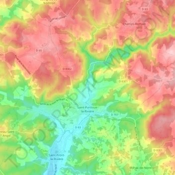
Saint-Pardoux-la-Rivière topographic map
Interactive map
Click on the map to display elevation.
Saint-Pardoux-la-Rivière
The topographically lowest point in the commune with 132 meters above sea level is situated at the southern exit of the Dronne near Jamaye, the highest point with 332 meters above sea level near Bos Brûlat in the very northeastern corner.
About this map
Name: Saint-Pardoux-la-Rivière topographic map, elevation, terrain.
Average elevation: 228 m
Minimum elevation: 126 m
Maximum elevation: 324 m
Other topographic maps
Click on a map to view its topography, its elevation and its terrain.
Le Clau du Bois
France > Nouvelle-Aquitaine > Dordogne > Saint-Romain-et-Saint-Clément
Average elevation: 221 m
La Croix de Ruchal
France > Nouvelle-Aquitaine > Dordogne > Rouffignac-Saint-Cernin-de-Reilhac
Average elevation: 239 m
Château de Castelnaud-la-Chapelle
France > Nouvelle-Aquitaine > Dordogne > Castelnaud-la-Chapelle > Castelnaud
Average elevation: 146 m