
Make a donation
Gear up for your next adventure:
As an Amazon Associate, this site earns from qualifying purchases at no extra cost to you.
Mylavaram topographic map
Click on the map to display elevation.
Make a donation
Gear up for your next adventure:
As an Amazon Associate, this site earns from qualifying purchases at no extra cost to you.
Mylavaram
Mylavaram is located at 16°47′00″N 80°38′00″E / 16.7833°N 80.6333°E / 16.7833; 80.6333. It has an average elevation of 47 metres (157 feet).
Make a donation
Gear up for your next adventure:
As an Amazon Associate, this site earns from qualifying purchases at no extra cost to you.
About this map
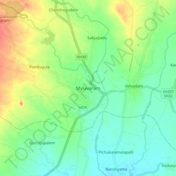
Name: Mylavaram topographic map, elevation, terrain.
Location: Mylavaram, NTR, Andhra Pradesh, 521230, India (16.72120 80.60182 16.80120 80.68182)
Average elevation: 59 m
Minimum elevation: 40 m
Maximum elevation: 90 m
Make a donation
Gear up for your next adventure:
As an Amazon Associate, this site earns from qualifying purchases at no extra cost to you.