
Gemeinde Raggal topographic map
Interactive map
Click on the map to display elevation.
About this map
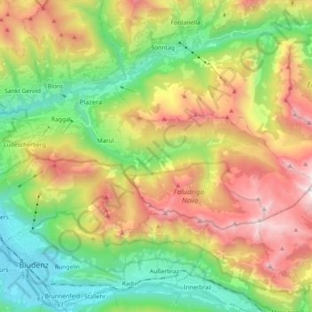
Name: Gemeinde Raggal topographic map, elevation, terrain.
Location: Gemeinde Raggal, Bezirk Bludenz, Vorarlberg, 6741, Österreich (47.16681 9.80452 47.22396 9.98308)
Average elevation: 1,313 m
Minimum elevation: 551 m
Maximum elevation: 2,442 m
Die Gemeinde liegt im westlichsten Bundesland Österreichs, Vorarlberg, im Bezirk Bludenz auf durchschnittlich 1015 m ü. A. Höhe. Das gesamte Gemeindegebiet liegt im UNESCO Biosphärenpark Großes Walsertal. 47 % der Fläche sind bewaldet, 19 % der Fläche Alpen. Es gibt ca. 50 landwirtschaftliche Betriebe. Die ganzjährigen Höfe und Häuser reichen von ca. 770 m Seehöhe bis ca. 1150 m.
Other topographic maps
Click on a map to view its topography, its elevation and its terrain.
Marul
Österreich > Vorarlberg > Gemeinde Raggal > Marul
Marul, Gemeinde Raggal, Bezirk Bludenz, Vorarlberg, 6741, Österreich
Average elevation: 1,282 m